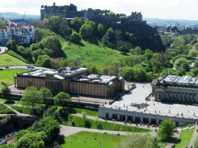
Bounded by the Firth of Forth to the north and the Pentland Hills, which skirt the periphery of the city to the south, Edinburgh lies in the eastern portion of the Central Lowlands of Scotland. The city sprawls over a landscape which is the product of early volcanic activity and later periods of intensive glaciation. Igneous activity between 350 and 400 million years ago, coupled with faulting led to the dispersion of tough basalt volcanic plugs, which predominate over much of the area. One such example is Castle Rock which forced the advancing icepack to divide, sheltering the softer rock and forming a mile-long tail of material to the east, creating a distinctive crag and tail formation. Glacial erosion on the northern side of the crag gouged a large valley resulting in the now drained Nor Loch. This structure, along with a ravine to the south, formed an ideal natural fortress which Edinburgh Castle was built upon. Similarly, Arthur's Seat is the remains of a volcano system dating from the Carboniferous period, which was eroded by a glacier moving from west to east during the ice age. Erosive action such as plucking and abrasion exposed the rocky crags to the west before leaving a tail of deposited glacial material swept to the east. This process formed the distinctive Salisbury Crags, which formed a series of teschenite cliffs located between Arthur's Seat and the city centre. The residential areas of Marchmont and Bruntsfield are built along a series of drumlin ridges located south of the city centre which were deposited as the glacier receded.
Other viewpoints in the city such as Calton Hill and Corstorphine Hill are similar products of glacial erosion. The Braid Hills and Blackford Hill are a series of small summits to the south west of the city commanding expansive views over the urban area of Edinburgh and northwards to the Forth.
Edinburgh is drained by the Water of Leith, which finds its source at the Colzium Springs in the Pentland Hills and runs for 29 kilometres (18 mi) through the south and west of the city, emptying into the Firth of Forth at Leith. The nearest the river gets to the city centre is at Dean Village on the edge of the New Town, where a deep gorge is spanned by the Dean Bridge, designed by Thomas Telford and built in 1832 for the road to Queensferry. The Water of Leith Walkway is a mixed use trail that follows the river for 19.6 kilometres (12.2 mi) from Balerno to Leith.
The Water of Leith at Juniper GreenDesignated in 1957, Edinburgh is ringed by a green belt stretching from Dalmeny in the west to Prestongrange in the east. With an average width of 3.2 kilometres (2 mi) the principal objective of the green belt was to contain the outward expansion of Edinburgh and to prevent the agglomeration of urban areas. Expansion within the green belt is strictly controlled but developments such as Edinburgh Airport and the Royal Highland Showground at Ingliston are located within the zone. Similarly, urban villages such as Juniper Green and Balerno sit on green belt land. One feature of the green belt in Edinburgh is the inclusion of parcels of land within the city which are designated as green belt even though they do not adjoin the main peripheral ring. Examples of these independent wedges of green belt include Holyrood Park and Corstorphine Hill.
 Areas of Edinburgh
Edinburgh, the capital of Scotland, is divided into areas that generally encompass a park (sometimes known as "links"), a main local street (i.e. street of local retail shops), a high street (the historic main street, not always the same as the main local street, such as in Corstorphine) and residential buildings. In Edinburgh many residences are tenements, although the more southern and western parts of the city have traditionally been more affluent and have a greater number of detached and semi-detached villas.
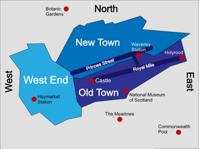
The historic centre of Edinburgh is divided into two by the broad green swath of Princes Street Gardens. To the south the view is dominated by Edinburgh Castle, perched atop the extinct volcanic crag, and the long sweep of the Old Town trailing after it along the ridge. To the north lies Princes Street and the New Town. The gardens were begun in 1816 on bogland which had once been the Nor Loch.
To the immediate west of the castle lies the financial district, housing insurance and banking buildings. Probably the most noticeable building here is the circular sandstone building that is the Edinburgh International Conference Centre.
Old Town
The Old Town has preserved its medieval plan and many Reformation-era buildings. One end is closed by the castle and the main artery, the Royal Mile, leads away from it; minor streets (called closes or wynds) lead downhill on either side of the main spine in a herringbone pattern. Large squares mark the location of markets or surround public buildings such as St. Giles' Cathedral and the Law Courts. Other notable places nearby include the Royal Museum of Scotland, Surgeons' Hall and McEwan Hall. The street layout is typical of the old quarters of many northern European cities, and where the castle perches on top of a rocky crag (the remnants of an extinct volcano) the Royal Mile runs down the crest of a ridge from it.
Due to space restrictions imposed by the narrowness of the "tail", the Old Town became home to some of the earliest "high rise" residential buildings. Multi-storey dwellings known as lands were the norm from the 16th century onwards with ten and eleven stories being typical and one even reaching fourteen stories. Additionally, numerous vaults below street level were inhabited to accommodate the influx of immigrants during the Industrial Revolution. These continue to fuel legends of an underground city to this day. Today there are tours of Edinburgh which take you into the underground city, Edinburgh Vaults.
New Town
The New Town was an 18th century solution to the problem of an increasingly crowded Old Town. The city had remained incredibly compact, confined to the ridge running down from the castle. In 1766 a competition to design the New Town was won by James Craig, a 22-year-old architect. The plan that was built created a rigid, ordered grid, which fitted well with enlightenment ideas of rationality. The principal street was to be George Street, which follows the natural ridge to the north of the Old Town. Either side of it are the other main streets of Princes Street and Queen Street. Princes Street has since become the main shopping street in Edinburgh, and few Georgian buildings survive on it. Linking these streets were a series of perpendicular streets. At the east and west ends are St. Andrew Square and Charlotte Square respectively. The latter, designed by Robert Adam, influenced Edinburgh street architecture into the early 19th century. Bute House, the official residence of the First Minister of Scotland, is on the north side of Charlotte Square. Sitting in the glen between the Old and New Towns was the Nor Loch, which had been both the city's water supply and place for dumping sewage. By the 1820s it was drained. Craig's original plans included the ornamental Princes Street Gardens and a canal in place of the Nor Loch. Excess soil from the construction of the buildings was dumped into the loch, creating what is now The Mound and the canal idea was abandoned. In the mid-19th century the National Gallery of Scotland and Royal Scottish Academy Building were built on The Mound, and tunnels to Waverley Station driven through it. The New Town was so successful that it was extended greatly. The grid pattern was not maintained, but rather a more picturesque layout was created.


